The eruption occurred at around 4am UTC (12pm Singapore time) from the large Hunga Tonga-Hunga Ha’apai volcano located about 65 km north of the island of Tongatapu where the capital city of Tonga, Nuku’alofa, is located.

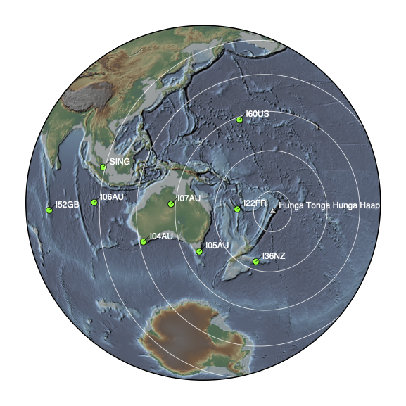
Map showing the location of the volcano (white triangle) as well as the Southeast Asian and Western Pacific infrasound stations (green circles). The concentric circles indicate different distances from the volcano: 1, 3, 5, 7 and 9 thousands of kilometres (Source: Kyle Bradley using tectoplot/Earth Observatory of Singapore)
The volcano is mostly underwater and comprises a large submerged caldera about 6 km wide. The volcano has been active in recent years, with eruptions in 2009, 2014, and 2015 from the edge of the caldera. The current activity started in December 2021 and a large explosion was observed just one day before the eruption on 15 January.
Volcanic eruptions releasing a mass of gas and/or magma into the atmosphere in an explosive way can produce an abrupt change in pressure called a shock wave. Shock waves can travel large distances in the air and be recorded by instruments both locally and globally.
The shock wave from the 15 January eruption was recorded by many infrasound stations and weather stations in the region. As Singapore is approximately 9,000 km away from the eruption, the signal from this shock wave took about eight hours to reach our sensors and was recorded at around 8:10pm local time the same day. Following the shock wave, the eruption signal lasted for about three hours on our sensors. Moreover, the shock wave travelled in all directions and was so strong that our Singapore sensors recorded a subsequent signal on 16 January at 3:31pm local time from the shock wave that travelled the opposite way around the globe.
"This is an extraordinary signal because of its strength and it is rare for a volcano to generate a sound loud enough that it circles the globe," said Ms Anna Perttu, a Research Associate at EOS who has worked on infrasound signals from many eruptions in Southeast Asia and worldwide. Another eruption that has generated a loud sound that circled the globe is that of Krakatau volcano in Indonesia in 1883. It was recorded at that time by barometers all around the world and is now considered a pioneering event in infrasound monitoring studies.

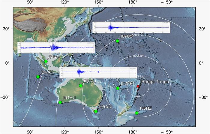
Map of Southeast Asia and Pacific region showing the location of the volcano (red triangle) and the regional infrasound stations (green circles). We also show the infrasound signal recorded at three stations (SING, I60US and I07AU). SING is a station located in Singapore from the Earth Observatory of Singapore. (Source: Anna Perttu and Kyle Bradley using tectoplot/Earth Observatory of Singapore)
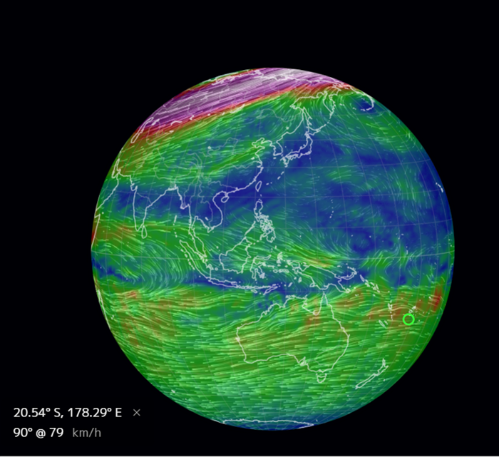
Sound waves travel in the air at an average speed of 330 metres per second. If the sound wave had travelled from the volcano to Singapore at this speed, it would have arrived about 30 minutes earlier than the time we recorded. The difference in arrival time is because many parameters affect the sound signal as it travels from the eruption vent to the different stations. These parameters include the atmospheric temperature, wind direction, and intensity. The main winds at an altitude of 25 km are currently flowing east-west around Tonga and in the southern hemisphere in general, while the winds over Singapore are travelling west-east. This could have delayed the signal to reach the Singapore station.
"The Hunga Tonga-Hunga Ha’apai eruption was so powerful that it was detected worldwide and multiple times even if the atmospheric conditions were sometimes unfavourable," said Dr Dorianne Tailpied, a Research Fellow at EOS who specialises in infrasound propagation and attenuation modelling. "This spectacular event gives us a unique opportunity to study infrasound propagation as well as the use of infrasound as a monitoring technique."

Wind map showing that current winds around Tonga are in the East-West direction (Source: earth.nullschool.net)
This eruption was even heard in New Zealand and was instrumentally recorded in the audible range as far away as Alaska, but not in Singapore. Our sensors show that thesignal in Singapore is below the audible threshold of 20 hertz. This is likely because the higher frequency and audible part of the signal weakened as it travelled from the volcano to the Singapore sensor.

The infrasound signal recorded in Singapore has a frequency below 20 Hz, which is below the frequency humans can hear (Source: Anna Perttu/Earth Observatory of Singapore)
Infrasound data can help identify the start time, duration, and relative intensity of an eruption. Using the acoustic power, scientists from EOS can also quantify the energy released during the eruption and provide information about the plume such as the estimated plume height. They will be able to provide accurate estimates when more data, such as the area of the volcanic vent, become available.
Many underwater volcanoes can affect the communities and infrastructure of Southeast Asia,but their eruptive histories and potential hazards are not well understood. "The impacts that volcanoes can have locally, regionally, and globally, regardless of how remote they are, area constant reminder that continuing research in this field is needed," said Associate Professor Benoit Taisne, a Principal Investigator at EOS who uses a range of techniques, including laboratory experiments and monitoring data such as infrasound, to understand the dynamics of magmatic systems with a focus on Southeast Asia volcanoes.