The Earth Observatory of Singapore (EOS) launched the first of four new stations to better monitor changes to Singapore's land height and sea levels.
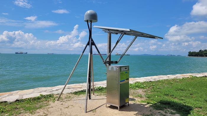
Installed in May 2023, the new Global Navigation Satellite System (GNSS) station is located at Lazarus Island. It collects data from a range of satellites and sends them back to EOS, for researchers to analyse and estimate land-height and sea-level changes at and around Lazarus Island. This contributes towards better monitoring and understanding local sea-level rise in Singapore.

EOS GNSS station at Lazarus Island that monitors land-height and sea-level changes (Source: Nurdin Dahlan/Earth Observatory of Singapore)
The station was installed and will be maintained by the EOS Centre for Geohazard Observations (CGO), to support EOS research in tectonics and climate. "Our research shows that land-height changes can be significant and variable across the region, which affects local sea-level rise. We need more stations to capture this variability and monitor both land-height and sea-level changes at a local scale," said Professor Emma Hill, Chair of the Asian School of the Environment and Principal Investigator at EOS.
EOS plans to install the second station in Punggol, with the third and final locations to be determined.
The stations will be integrated to the Singapore Satellite Positioning Reference Network (SiReNT) of the Singapore Land Authority (SLA), as part of a partnership between EOS and SLA inked in June 2022.
"The installation of new GNSS stations in Singapore is part of an EOS initiative to understand sea-level changes in Singapore and the region," said Mr Leong Choong Yew, Director of the EOS CGO. The team previously installed two GNSS stations in Taiwan, and it will continue exploring new locations to further strengthen EOS capacity to monitor tectonic activity and climate change in the region.
See media coverage by Nanyang Technological University (NTU) Singapore on NTU News.