Project Overview
The 2008 Mw7.9 Wenchuan earthquake ruptured an imbricate thrust system in the Longmenshan range, which forms the eastern boundary of the Tibetan Plateau. We use seismic reflection data and surface geology to construct geologic cross sections and a three-dimensional (3D) fault model in the range front. The rupture was complex, with slip on both the steeply dipping Beichuan fault and the more shallowly dipping Pengguan fault, which appear to merge at depth. In contrast, only the Beichuan fault ruptured in the north, with the transition near a lateral fault offset. Thus, the earthquake involved multiple thrust splays and breached a significant segment boundary.
To investigate the tectonic setting of the earthquake, we extend our previous measurements of crustal shortening the interior of the range and show that shortening correlates with topography. This suggests that upper-crustal shortening can produce the high topography of the Longmen Shan without calling on other uplift mechanisms. Based on this understanding, we model the thrust belt as a critical taper wedge, to assess what rock and fault strengths are required to explain the topographic slopes within the range front and basin. The low taper within the basin is consistent with a weak detachment (coefficient of friction ≈ 0.1), while a slightly stronger (coefficient of friction ≈ 0.3–0.4) detachment is necessary to explain the higher taper of the range front. This difference may relate to the localization of the detachment within a Triassic evaporite sequence within the basin, while the faults beneath the range front are rooted in Precambrian metasedimentary or igneous rocks.
Critical taper theory implies that shortening in the range front where the 2008 Wenchuan earthquake occurred is many times greater than in the basin, consistent with our shortening measurements. We examine the implications of these findings for seismic hazard assessment in the region and in other active mountain belts around the world.
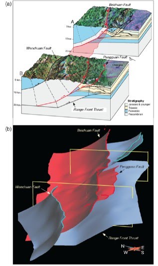
Figure 1: (a) Perspective view of the eastern Longmen Shan looking to the northeast, showing cross sections A-A’ and B-B’ of Figure 1. Major faults are shown. The surface shows a Landsat image draped on a DEM. (Figure after Xu et al., 2009.) (b) View of the 3D model produced in GOCAD from the same perspective. Wenchuan rupture is composed of Beichuan and Pengguan faults; the upper detachment, Range Front thrust, lower detachment, northern frontal faults, and Wenchuan fault are also shown. Boxes indicate the locations of cross sections A-A’ and B-B’, which were used to construct the model.
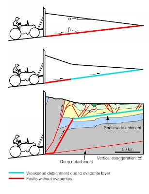
Figure 2: Conceptual models of (a) simple single-taper critical taper wedge and (b) double-taper critical taper wedge. (c) Cross section of the Sichuan basin and eastern Longmen Shan with thickened faults indicating the basal detachment. Weakened detachment due to evaporite layer and faults without evaporites are distinguished. Topography in (c) is the mean swath topography.. Two wedge zones are defined here: the Sichuan basin, which has a shallow, weak detachment and a shallow surface slope, and the frontal Longmen Shan, which has a strong basal detachment and a steep surface slope. The color version of this fig- ure is available only in the electronic edition.