ARIA-SG Project

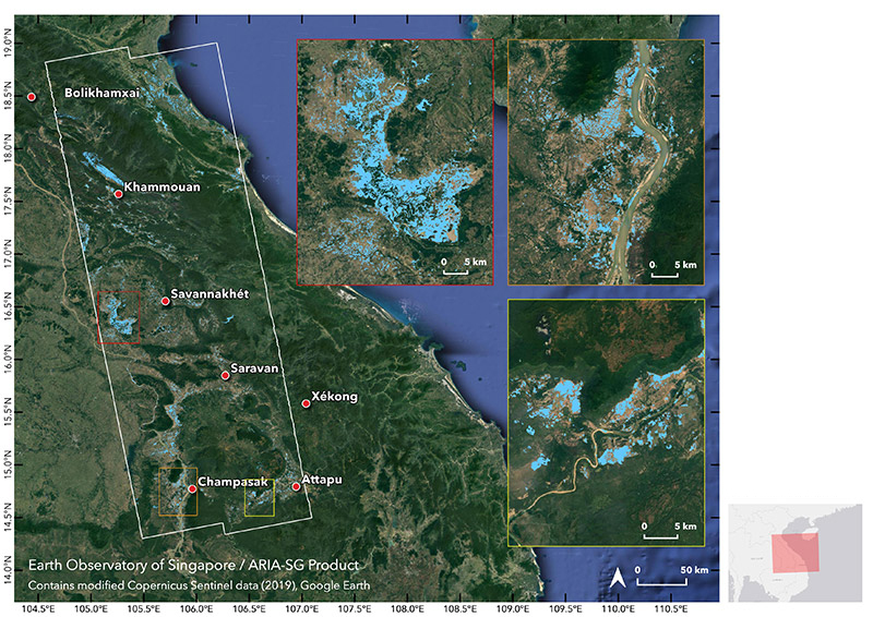
ARIA-SG Flood Proxy Map: Laos Floods, 6 Sep 2019, v0.1 This preliminary map shows areas that are likely flooded (shown by light blue pixels of 30 m in size) in southern Laos due to heavy rains brought by Tropical Storm Podul a week before, and Tropical Depression Kajiki. The map extents are indicated by the white polygon. This map should be used as a guidance to identify areas that are likely flooded, and is less reliable over urban and vegetated areas. Derived from synthetic aperture radar data acquired by the Copernicus Sentinel-1 satellites operated by the European Space Agency (ESA) before (3 Apr) and during (6 Sep) the event. Analysed by the ARIA-SG team at the Earth Observatory of Singapore (EOS), using the ARIA-SG system originally developed by NASA-JPL and Caltech. Data processing used an AWS Open Dataset of Copernicus Sentinel-1 data for the Asia region (https://registry.opendata.aws/sentinel1-slc-seasia-pds).

The aims of this project are to use remote-sensing data to:
• Support regional and local stakeholders and decision makers by monitoring and mapping regional hazards, environmental crises, and natural disasters
• Develop cutting-edge algorithms for hazards monitoring and disaster mapping (e.g., using machine learning techniques).
 

In particular, we are using Synthetic Aperture Radar (SAR) to make timely maps of disasters (e.g., flood extents, building damage from earthquakes and typhoons) for post-disaster situations, and to provide routine monitoring of ground deformation that is related to potential hazards.

This project is in collaboration with the NASA Jet Propulsion Laboratory and Caltech, and uses their Advanced Rapid Imaging and Analysis (ARIA) system to process the SAR data in a cloud-computing environment.

Disaster-response maps from this project can be downloaded at:
http://ariasg-products.earthobservatory.sg/

Updates on our work, including posting of disaster-response products can be found at:
https://twitter.com/eos_aria

Funding Sources

  • Earth Observatory of Singapore
  • National Research Foundation

Project Years

2018, 2019, 2020

Related Projects

Fault geometries and histories in western Nepal and implications for seismic hazards

The 2015 Mw7.8 Gorkha earthquake, Nepal, was a reminder of the seismic hazard presented by the Himal...
Read Project Details

Bangladesh: Active Faults in the Chittagong-Tripura Fold Belt

To the west of the Intraplate Deformation zone, across the Indo-Burma Ranges, lies another large con...
Read Project Details

The impact of fault-bend folding and high resolution bathymetry on models of tsunami generation

In subduction zones, the greatest hazard from earthquakes often comes from tsunami waves. However, m...
Read Project Details

TREMBLE (Temporary REceivers for Monitoring BangLadesh Earthquakes)

The country of Bangladesh sits in a complex tectonic region on the eastern side of the India-Asia co...
Read Project Details

Slip rates and base level changes on the Main Frontal Thrust, Nepal

In 2014 and 2015, the Structural Geology group at EOS conducted seismic reflection acquisition in Ne...
Read Project Details

Publications

Year 2020

Rapid flood and damage mapping using synthetic aperture radar in response to Typhoon Hagibis, Japan

Cheryl W.J. Tay, Alok Bhardwaj, Emma M. Hill, Jungkyo Jung, Sang-Ho Yun, & Shi Tong Chin

The Team

Emma HILL

Emma HILL

Principal Investigator

Subscribe to the EOS Newsletter

Stay in touch with the latest news, events, research, and publications from the Earth Observatory of Singapore.

Email is required

Email is wrong format

You Can Make a Difference

Partner with us to make an impact and create safer, more sustainable societies throughout Southeast Asia.
Make A Gift